
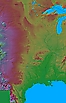
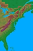
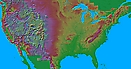
These are large area maps: three of them cover one third of the country each (in 20 degree wide strips) and the fourth covers the entire country (60 degrees wide by 25 degrees high). At full resolution, each pixel corresponds to 30 seconds of arc (about half a mile in the North-South direction). The heights are based on data that distinquishes 20 feet of elevation. I've included lower resolution versions too, as the high resolution images are quite large files.
The images here are mosaics that I assembled from 5 degree tiles created by Ray Sterner at Johns Hopkins University. Ray has also created individual maps of each U.S. state, together with related information. The tiles are copyright by Ray Sterner. The mosaics are copyright © 1995 Andrew Birrell. All rights reserved.
The images are based on digital elevation model (DEM) data from the USGS. The USGS also offer free programs for manipulating DEM and other data. See also the shaded maps available at USGS, NOAA, and Digital Wisdom (commercial). For general maps, see the Perry-Castañeda library map collection.

- 30 seconds/pixel (2295 by 2867 pixels, 4.1 MBytes).
- 1 minute/pixel (1148 by 1434 pixels, 1.0 MBytes).
- 2 minutes/pixel (546 by 689 pixels, 424 KBytes).
- 30 seconds/pixel (2295 by 3556 pixels, 3.0 MBytes).
- 1 minute/pixel (1148 by 1778 pixels, 690 KBytes).
- 2 minutes/pixel (546 by 861 pixels, 402 KBytes.
- 30 seconds/pixel (2295 by 3556 pixels, 2.3 MBytes).
- 1 minute/pixel (1148 by 1778 pixels, 552 KBytes).
- 2 minutes/pixel (546 by 861 pixels, 257 KBytes).
- 30 seconds/pixel (6636 by 3556 pixels, 9.3 MBytes).
- 1 minute/pixel (3332 by 1778 pixels, 2.1 MBytes).
- 2 minutes/pixel (1638 by 861 pixels, 1.1 MBytes).
- miniature (655 by 345 pixels, 186 KBytes).
- full resolution PNG (6636 by 3556 pixels, 25 MBytes).
The full resolution PNG file lets you see the original rendered pixels,
without any distortion introduced by the JPEG encoding of the other versions.
![]() Home
Home